Plan Your Visit
Patient Resources
- Make an Appointment
- Pay Your Bill
- myChart Patient Website
- Financial Counseling
- Medical Records Requests
- Radiology Requests
- Price Transparency
From Worcester: Take Route I-290 to Route I-190 North to Exit 6 (Route 12, Sterling) to Route 62 East, Clinton. Follow the blue "H" (hospital) signs about 2.1 miles. At the flashing yellow light, take a left onto Highland Street. At the corner of Highland Street and Greeley Street, turn left. The hospital entrance is on the right.
From Route 495:
Berlin: Take Exit 26 (Route 62 West) to Clinton. Turn left at the end of the ramp. (Do not follow the blue hospital sign for Marlborough Hospital). Continue on Route 62 toward Sterling. Follow the blue "H" (hospital) signs approximately 6.3 miles to Main Street/Routes 62/70 in Clinton. Turn right onto Main Street. At third set of lights turn left to stay on Route 62/Brook Street. Follow about 0.3 miles, then turn right onto Greeley Street.The hospital's entrance is at the top of the hill on the right.
Bolton: Take Exit 27. Turn right off the exit onto Route 117/Main Street. Follow for 0.8 miles, and turn left onto Watoquadoc Road. Follow for approximately 3 miles. Watoquadoc Road becomes Bolton Road, then Water Street in Clinton. Stay on Water Street for 1 mile. At the second set of lights go right onto Route 62/70. At first set of lights, turn left to stay on Route 62/Brook Street. Follow about 0.3 miles, then turn right onto Greeley Street. The hospital's entrance is at the top of the hill on the right.
From Route 2: Take Exit 35 (Route 70, Lunenburg Road/Lancaster). Follow signs for Lancaster. At the junction of Route 117, turn left onto Main Street. In about 0.2 miles, turn right at the flashing yellow light to stay on Main Street. Follow Route 70 for approximately 2 miles. Take a slight right onto Sterling Road, then a left onto Parker Road, which leads to the hospital.
From Sterling and Princeton: Take Route 62 East toward Clinton. Follow the blue "H" (hospital) signs approximately 4.1 miles from Sterling center and 10.7 miles from Princeton center. At the flashing yellow light in Clinton, take a left onto Highland Street. At the corner of Highland Street and Greeley Street, turn left. The hospital entrance is on the right.
Ample free parking is available on all of the HealthAlliance-Clinton Hospital campuses. See below for details.
Fitchburg Campus:
Visitor parking lots can be found near Entrances 1, 2, 3, 4. Signs are located at both campuses to tell you where to park.
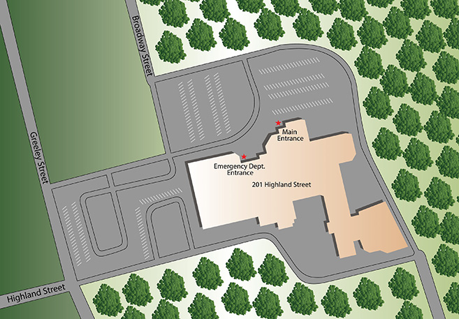
Clinton Campus:
Visitor parking is available in front and on the side of the hospital. Patients may be dropped off at the covered main or emergency entrances.
Leominster Campus:
Visitor parking lots can be found near Entrances B, D, E, and F. Motorists may drop patients and visitors off adjacent to the Main Entrance B and Diagnostic Imaging (Radiology) Department, and then park on the parking deck.
Fitchburg and Leominster Campuses:
Clinton Campus:
For a complete list of taxicab services in and around the region this online directory can help you call the taxicab service of your choice.

 Exclusive Health Care Provider for the Worcester Red Sox.
© 2024 UMass Memorial Health